Skip to content

Loretta C. Duckworth Scholars Studio

⠀

Menu
  • Scholars Studio Blog
    • Digital Methods
      • coding
      • critical making
      • data visualization
      • digital pedagogy
      • immersive technology (AR/VR)
      • mapping
      • textual analysis
      • web scraping
    • Disciplinary Fields
      • Anthropology
      • Archaeology
      • Architecture
      • Art History
      • Business
      • Computer Science
      • Critical Digital Studies
      • Cultural Studies
      • Dance
      • Economics
      • Education
      • Environmental Studies
      • Film Studies
      • Gaming Studies
      • Geography
      • History
      • Information Science
      • Linguistics
      • Literary Studies
      • Marketing
      • Media and Communication Studies
      • Music Studies
      • Political Science
      • Psychology
      • Public Health
      • Sculpture
      • Sociology
      • Urban Studies
      • Visual Art
    • Cultural Analytics Practicum Blogposts
  • Current Staff
  • Newsletter
  • About
    • Games Group 
Menu

Location Assessment in Abu Sayyaf Group Attacks

Posted on November 19, 2015November 30, 2017 by

By Joyce Rasing


In my first blog, I geolocated attack points by the Abu Sayyaf Group (ASG) by location. Most of these occurred in the Autonomous Region in Muslim Mindanao (ARMM) but not all of them—some of them occurred in Metropolitan Manila (the Philippines’ capital), and some of them have even occurred internationally. I intentionally omitted points that did not occur in the Philippines and am narrowing down to attacks that have occurred in the ARMM. Later, however, I will take a look at the attacks that I have omitted.

The issue with the Global Terrorism Database (GTD)’s latitude and longitude values that I geolocated in the first stage was that some of these attack locations used the same latitude and longitude, even though they occurred at different times and that is not because they actually did occur in the same location. The GTD left a note near the latitude and longitude coordinates regarding coordinate/geocoding specificity. This indicates terrorist attacks occurred with a specificity ranging from 1-5, meaning the exact location to an unknown location, respectively. The coordinates cannot always be as accurate as research needs them to be, and that is a limitation among many other things[1].

The 300 terrorist campaigns/terrorist attacks committed by the Abu Sayyaf Group listed by the GTD indicate an ambiguity level of 4 on the range of 1-5 specificity classification. The GTD likes the term “administrative region,” and ranks them by specificity of coordinates that they have provided by first and second order administrative regions. Philippine administrative regions work in this fashion: Region > Provinces > Municipalities/Cities > Barangays[2].

In the cases of administrative regions, New Cabalan is a barangay within Olongapo City (Municipality) in Zambales (Province) in Luzon (northern islands of the Philippines). I passed through here in February 2015 during my trip to the Philippines.

The level 4 classification means that a second order administrative region is not identified and the coordinates were placed in the first order administrative region. However, what I noticed about this classification was that the coordinates were not exactly placed with the method in which the GTD Codebook states. For instance, eight terrorist attacks that occurred on the island of Sulu had the same coordinates, with a ten year range (2002-2012). With Jolo being the municipality, the coordinates seemed to have taken the coordinates of a previous attack rather than the centroid of the municipality.

Walled City is a barangay within Jolo, Philippines.
Walled City is a barangay within Jolo, Sulu. The other labeled barangays exist within the municipality of Jolo. The coordinates of unknown locations for armed assault attacks that occurred in Jolo, Sulu were all placed in this area.


Another closer look at the unknown coordinate locations for armed assault in the original map in Google aerial maps.

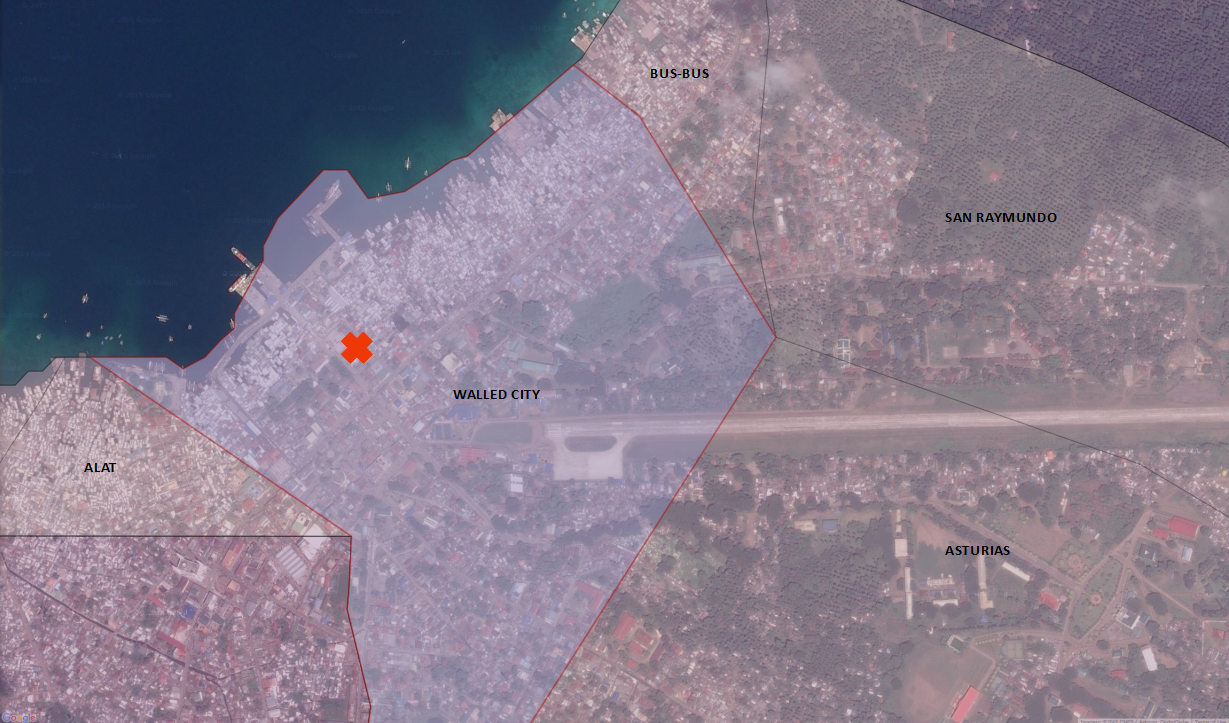
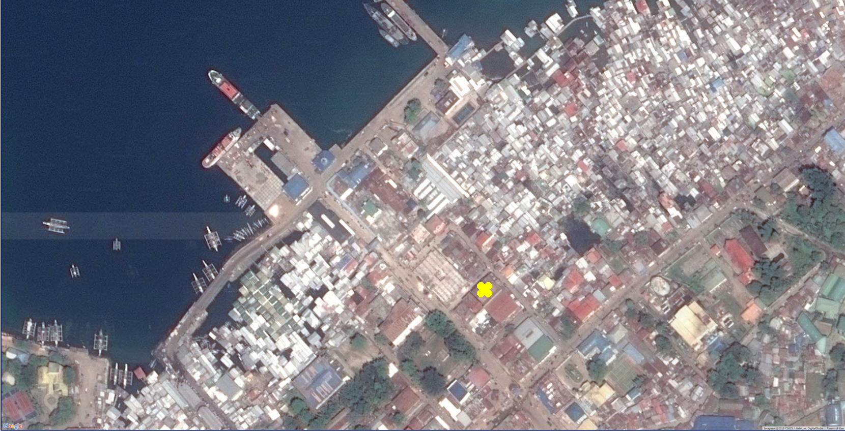
The main issue is that because of these unknown exact coordinates, it can skew the analysis of methods and terrain usage of the ASG. However, for a test and micro-analysis, I looked at the island of Sulu and flipped through different classifications of modes of attack[3]. It is clear that, even from the 3D terrain modeling from my last post, the ASG typically chooses urban areas for their attacks. The ASG does not really like to stray away from arterial roads on this island (especially since it is a smaller one)—for any mode of attack; not just armed assault. The majority of attack locations that use coordinates that seem to be located further away from what appears to be a major road or urban area are really only a few hundred meters away from a major road. This helps inform me about the behavior of the ASG and the likelihood of their methods. With this in mind, I am taking note of these modes of attack and location on the ground, while collecting names of participatory leaders and members in these attacks for next semester’s network analysis portion of this project.

—

Sources:

National Consortium for the Study of Terrorism and Responses to Terrorism (START). Global Terrorism

      Database 1992-2010 Dataset (June 2015). Retrieved from http://www.start.umd.edu/gtd.

Philippine Standard Geographic Code, and Philippine Statistics Authority. “Provincial Summary: Number of Provinces, Cities, Municipalities, and Barangays, by Region.” List of
Municipalities. Last modified September 30, 2015. http://www.nscb.gov.ph/activestats/psgc/listmun.asp.

Notes:

[1] Other limitations include satellite or high resolution aerial photos of the islands, or even a drag-drop option for Google Street View for the islands. Major arterial roads are mapped throughout the islands, but the issue is that collector and other smaller roads are either not visibly mapped or plainly do not exist because of infrastructure differences.

[2] “Barangay” is similar to that of the “barrio,” meaning village, or the smallest administrative region. There are about 42,000+ barangays in the Philippines.

[3] Modes of attack delineated by the GTD include Armed Assault, Hostage Kidnapping, Assassination, Facility/Infrastructure Attacks, and Bombing. There may be some unknown attacks but they have been omitted at this stage.


Leave a Reply

You must be logged in to post a comment.

Recent Posts

  • The Untold History of Fletcher Street’s Stables April 21, 2025
  • Building an Immersive Archive of the Greek Orthodox Churches in Istanbul April 15, 2025
  • Tracing Influence in Genealogies of Communication Theory April 14, 2025

Tags

3D modeling 3D printing arduino augmented reality banned books coding corpus building critical making Cultural Heritage data cleaning data visualization Digital Preservation digital reconstruction digital scholarship film editing game design games gephi human subject research linked open data machine learning makerspace makerspace residency mapping network analysis oculus rift omeka OpenRefine Photogrammetry Python QGIS R SketchUp stylometry text analysis text mining textual analysis top news twitter video analysis virtual reality visual analysis voyant web scraping webscraping

Recent Posts

  • The Untold History of Fletcher Street’s Stables April 21, 2025
  • Building an Immersive Archive of the Greek Orthodox Churches in Istanbul April 15, 2025
  • Tracing Influence in Genealogies of Communication Theory April 14, 2025

Archives

Meta

  • Log in
  • Entries feed
  • Comments feed
  • WordPress.org

Archives

Blog Tags

3D modeling (11) 3D printing (14) arduino (8) augmented reality (5) banned books (3) coding (12) corpus building (4) critical making (7) Cultural Heritage (11) data cleaning (4) data visualization (11) Digital Preservation (3) digital reconstruction (9) digital scholarship (12) film editing (3) game design (3) games (6) gephi (3) human subject research (3) linked open data (4) machine learning (6) makerspace (8) makerspace residency (4) mapping (30) network analysis (17) oculus rift (8) omeka (3) OpenRefine (4) Photogrammetry (5) Python (8) QGIS (10) R (9) SketchUp (4) stylometry (8) text analysis (10) text mining (4) textual analysis (32) top news (102) twitter (5) video analysis (4) virtual reality (17) visual analysis (5) voyant (4) web scraping (16) webscraping (3)

Recent Posts

  • The Untold History of Fletcher Street’s Stables April 21, 2025
  • Building an Immersive Archive of the Greek Orthodox Churches in Istanbul April 15, 2025
  • Tracing Influence in Genealogies of Communication Theory April 14, 2025
  • From Theory to Practice: Weaving in Response to the Grid in the Global Context March 26, 2025
  • Visiting a Land of Twilight February 24, 2025

Archives

©2025 Loretta C. Duckworth Scholars Studio | Design: Newspaperly WordPress Theme
Menu
  • Scholars Studio Blog
    • Digital Methods
      • coding
      • critical making
      • data visualization
      • digital pedagogy
      • immersive technology (AR/VR)
      • mapping
      • textual analysis
      • web scraping
    • Disciplinary Fields
      • Anthropology
      • Archaeology
      • Architecture
      • Art History
      • Business
      • Computer Science
      • Critical Digital Studies
      • Cultural Studies
      • Dance
      • Economics
      • Education
      • Environmental Studies
      • Film Studies
      • Gaming Studies
      • Geography
      • History
      • Information Science
      • Linguistics
      • Literary Studies
      • Marketing
      • Media and Communication Studies
      • Music Studies
      • Political Science
      • Psychology
      • Public Health
      • Sculpture
      • Sociology
      • Urban Studies
      • Visual Art
    • Cultural Analytics Practicum Blogposts
  • Current Staff
  • Newsletter
  • About
    • Games Group