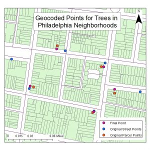
This final PHS project sought to create an address locator that would move points from the center of a parcel to just outside it. These points were to represent neighborhood trees. The process was completed and managed using address locator tools in ArcMap. Please refer to the image at the end for reference to the project results.
- First navigate in ArcToolbox to the following tool: Geocoding Tools/Create Address Locator
- Input the following information and create the geocoders:
- Parcels:
- Address Locator Style: General- Single Field
- Reference Data: City of Philadelphia PWD Parcels
- Key Field: ADDRESS
- Name: Parcels
- Streets:
- Address Locator Style: US- Dual Ranges
- Reference Data: Philadelphia Street Centerline
- Key Fields will fill in automatically
- Name: Streets
- Parcels:
- Editing the Street Geocoder for Accuracy:
- Once the Street geocoder is created right click on the tool in ArcCatalog
- Navigate to the properties
- Open the ‘Geocoding Options window
- Set ‘Side Offest’ to 25 feet.
- Apply changes and close the window
- Navigate to the following tool: Geocoding Tools/Geocode Addresses
- Input the following information to create geocoded points for trees using parcels:
- Input Table: Trees
- Input Address Locator: Parcels
- Input Address Fields: Key Field: ADDRESS
- Name: Trees_parcels
- Navigate to the following tool: Geocoding Tools/Reverse Geocode
- Input the following information to create final points using the street geocoder:
- Input Features: Trees_parcels
- Input Address Locator: Streets
- Output Feature Class: Final_trees