By Ryan Wheatley
In this blog post, I will detail my digital project to create a historic GIS landscape map focusing on the expansion of British and later American settlements (1680-1900’s) across the colonial landscape of Pennsylvania. Using the digital mapping tool, QGIS, I created a map of Pennsylvania cities, towns and incorporated boroughs under a pointillist approach. The goal was to represent Pennsylvania’s settlement expansion in relation to native historic markers and land purchases, serving as an educational tool for Pennsylvania’s colonial history and help educate others about native lands and rights.
Project Background
Much of early Pennsylvania history, namely that of William Penn and his sons, is taught as a peaceful acquisition of land and expansion with the colonial government negotiating with local nations such as the Lenni Lenape, now Delaware, for settlement rights. However, this history ignores and sometimes outright removes a more painful narrative of native nations forced from their lands by purchases they did not necessarily agree to and settlement expansion following violence against already set native settlements. This project attempts to shed some light onto that history not through discussing or dismissing that history, but by representing the expansion of settlements across the Pennsylvania landscape and the purchases that were made with many nations.
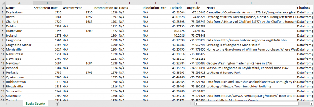
Started in August 2020 with graduate students Tauheedah Asad (MMC), Joe Makuc (History) and Stanley Schwartz (History), we began collecting data for each individual incorporated town, borough, and city in Pennsylvania. Specifically we looked for the settlements settled by date, incorporation date, and earliest known date plus the latitude and longitude for their placement on the map. We also included sections for Tract number should one be available, the date the first plot of land was Warranted to settlers, and dissolution dates should a settlement cease to be or split into multiple settlements. Finally, Notes and Citation columns were added for academic research purposes.
Building the Project
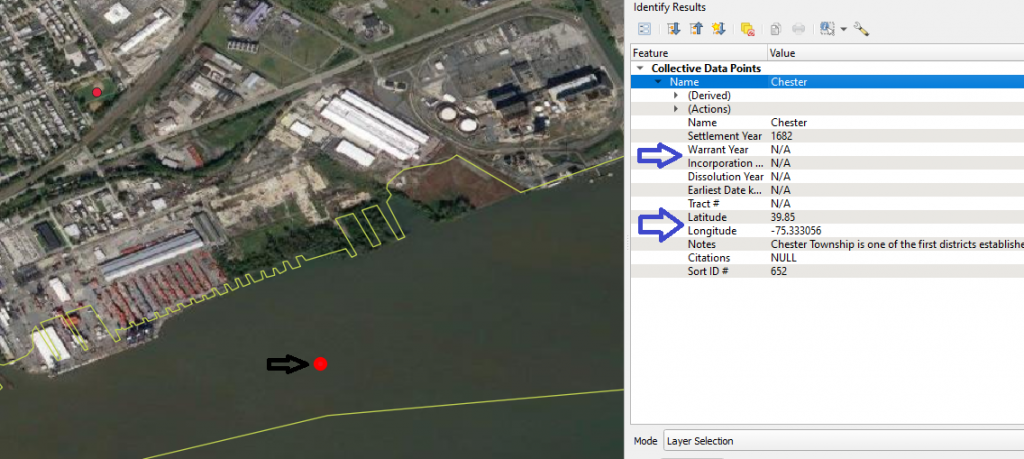
In collecting this data we poured over county and local histories written both by historians and primary documents detailing land sales. Online maps provided by the Pennsylvania State Historic Museum Commission and the Philadelphia Library helped tremendously in finding dates of purchase. Latitude and Longitudinal points were mostly placed at areas of historic significance or current governmental buildings to signify where the town center likely would be. For example, the site of Penn’s (actual) Landing was chosen for the city of Chester, Pennsylvania in Delaware County rather than their current government buildings due to its historical significance.
We chose a pointillist expression, representing our data as singular points across a larger landscape, over bordered-territory perspective as the landscape would have changed many times since colonization and would not be able to represent native settlement in an area realistically. We also worried a bordered perspective would reinforce the settlements as static entities that just existed and controlled the land, rather than each settlement having its own history of settlement and expansion.
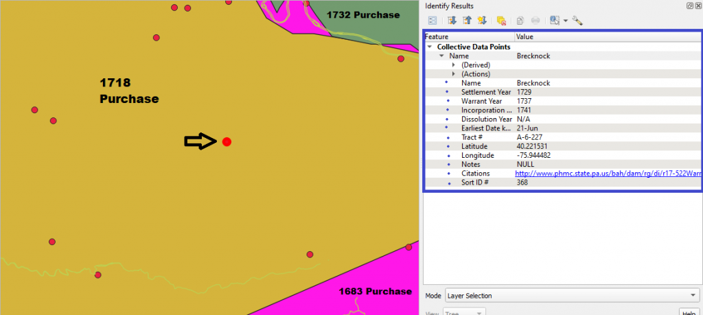
In December 2020, I took over the project in full and began contacting and working with the Delaware Nation to better represent native interests in the project at large. They asked for the incorporation of a purchases layer to represent the extent of settlements expanding prior to any land agreement which would further show Pennsylvania’s expansionist policies during the colonial era. These purchases of land were undertaken by Pennsylvania from initial settlement (1682) until a final purchase in 1792, involving many native nations in these actions. However, these purchases were rarely fair or followed in truth, with settlements appearing prior to the purchase and native groups still being forced off the land despite protections in the purchase treaties.
Furthermore, the map was removed of many native settlement representations, with our project now turning more towards settler expansion over the landscape than as a representational piece of prior native settlement in Pennsylvania. This site removal was intended to allow the many native nations that have historic homelands in modern-day Pennsylvania the authority to designate and represent their own sites on the map, rather than having them represented by the same data info as each of the colonial settlements.
List of Purchases and Purchase Map
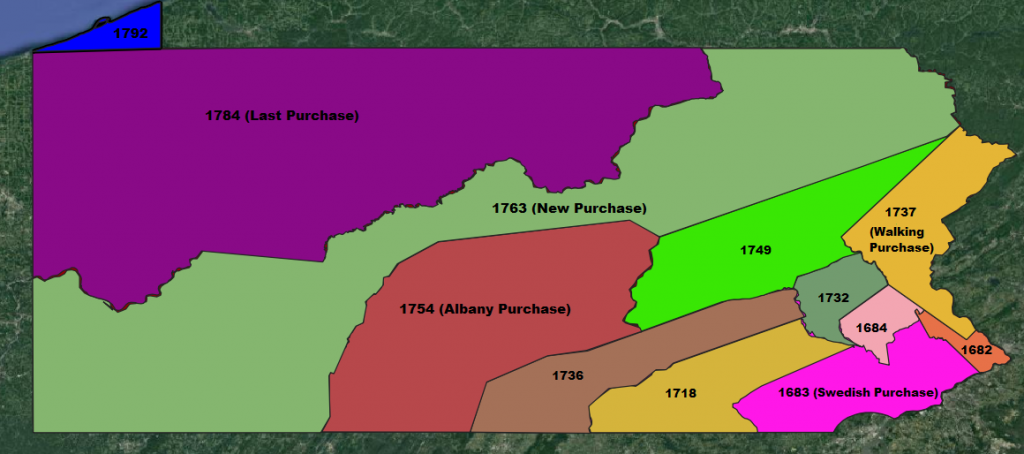
| Name | Background |
| 1682 Purchase | The initial purchase of land to settle Pennsylvania by William Penn. |
| 1683 Purchase | Negotiated between Great Britain and Sweden, with Britain taking over new Sweden’s claimed land. |
| 1684 Purchase | A small purchase of land to resolve some issues between the Lenape and William Penn, allotting to this border the 1683 purchase. Penn based much of his land sale of Pennsylvania off this treaty. |
| 1718 Purchase | The last purchase to involve William Penn, was an expansion of the early 1682 treaty. |
| 1732 Purchase | The first treaty involving William Penn’s sons, to expand the 1684 treaty boundaries. Penn’s sons had sold this land prior to making any official treaty. |
| 1736 Purchase | This purchase was made between the Haudenosaunee and Pennsylvania. The written treaty claimed more land than was agreed upon previous. |
| Walking Purchase (1737) | Started by Pennsylvania claiming a failed purchase in 1686 was valid, the colonial government forced the Lenape to negotiate. The Lenape were forced to allow the colony to take a certain tract of land that could be walked in a day. Pennsylvania scouted the land previously and were able to take much more than expected, and later removed the Lenape from the land despite the treaty forbidding it. |
| 1749 Purchase | This purchase was made between the colonial government and the Haudenosaunee at treaty signings for King George’s War. The written treaty took more land than negotiated. |
| Albany Purchase (1754) | Land obtained during the Albany Congress of 1754 between the northern colonial governments and the many native nations impacted by colonial expansion. Actually purchased by Connecticut from the Haudenosaunee, Pennsylvania claimed the land shortly after. |
| New Purchase (1768) | Land obtained by the Treaty of Fort Stanwix (1764) between Great Britain, The Six Nations of the Haudenosaunee, and the family of William Penn. While originally meant to help ease border tension, it only escalated it for another 5 years. |
| Last Purchase (1784) | Land obtained from the Treaty of Fort Stanwix (1784) from the Six Nations of the Haudenosaunee. Many natives refused to sign this treaty as it was a major blow to their independence. It was the first of many treaties between the US federal government and the Haudenosaunee. |
| 1792 Purchase | Called the “Triangle Purchase”, completed between Pennsylvania and the Six Nations of the Haudenosaunee in 1784. Multiple states claimed the land, and it took until 1792 for the Federal Government to grant it to Pennsylvania. |
Methodology
While the map started as us trying to refocus Pennsylvania’s early colonial narrative towards the native nations existing prior to colonization, the project became one of representing that colonial settlement over the landscape. This change did not remove the initial goal of representing the expansion and the ways it took place, however, with each data point still trying to tell a story of Pennsylvania expansion across the modern state. Many points contain short histories about how that expansion was undertaken, with most explaining the native settlement that existed there or nearby prior to colonization. The land purchase map also furthers a landscape expansion, as many settlements were founded prior to the land even being ‘purchased’ by Pennsylvania proper.
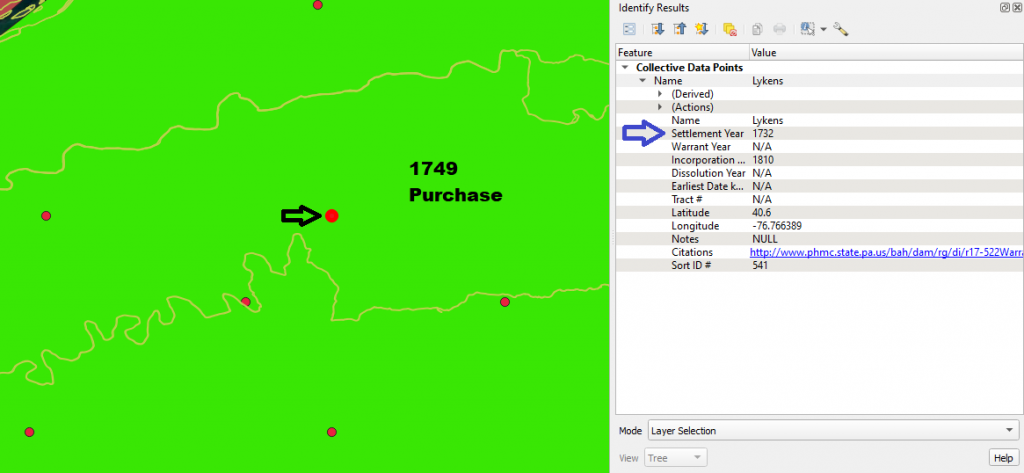
Even without the desired interactive component the map still says much about how misleading the current narrative is. Many settlement dates appear before any land was even ‘purchased’ by colonial governments and warrant dates show the land being sold before nearby land was even settled. The expansion also shows how Western Pennsylvania was settled earlier than most assume, with many settlements existing as fort towns initially. It shows that Pennsylvania, while representing a history of peaceful purchase expansion, still desired expansion into settled lands and did so without care for the people who lived there previously.
Current Status and Future Directions
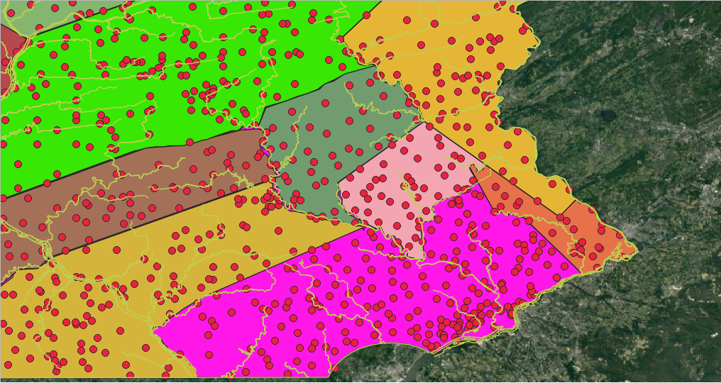
Currently the map has over 3000 data points of almost every town/city/borough in Pennsylvania with each point having at least a settlement date, incorporation date, latitude and longitude. The next step would be an incorporation of native-created data or data created under their auspices to reintegrate the native settlement focus, and the expansion to a fully interactive map. This interactive version would be publicly available and allow for in depth interaction with each data point given, detailing a history of the settlement and its creation. This will likely be conducted through ArcGIS Story Maps, though it is still undecided at this time. An expansion into bordering states could be done as well. For my own purposes I plan to use the map in my larger dissertation, tracking settlement patterns alongside historically noted trade routes and material connections between settlement collections.
Thank you to Marcus Bingenheimer, the Scholars Studio as a whole, and the Delaware Nations for assistance in this project.
Works Cited
Boyd, Julian P. (1938). Indian treaties printed by Benjamin Franklin, 1736-1762. Philadelphia, 1938.
Godcharles, F. Antes. (1933). Pennsylvania: Political, Governmental, Military and Civil. Vol.2, New York: The American historical society, inc.
Richter, Daniel K. (2005). Native Americans’ Pennsylvania. University Park, Pa.: Pennsylvania Historical Association.
Richter, Daniel K. (1992) The Ordeal of the Longhouse: The Peoples of the Iroquois League in the Era of European Colonization. Chapel Hill: The University of North Carolina Press.
Wallace, Paul A.W (1971). Indian Paths of Pennsylvania. Harrisburg : Pennsylvania Historical and Museum Commission
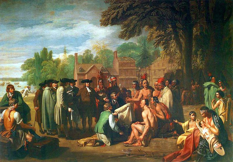
West, Benjamin (1771/2). “Treaty of Penn with the Indians”. Philadelphia: Pennsylvania Academy of Fine Arts
Data received from the Delaware Tribal Historic Preservation Office.
