Skip to content

Loretta C. Duckworth Scholars Studio

⠀

Menu
  • Scholars Studio Blog
    • Digital Methods
      • coding
      • critical making
      • data visualization
      • digital pedagogy
      • immersive technology (AR/VR)
      • mapping
      • textual analysis
      • web scraping
    • Disciplinary Fields
      • Anthropology
      • Archaeology
      • Architecture
      • Art History
      • Business
      • Computer Science
      • Critical Digital Studies
      • Cultural Studies
      • Dance
      • Economics
      • Education
      • Environmental Studies
      • Film Studies
      • Gaming Studies
      • Geography
      • History
      • Information Science
      • Linguistics
      • Literary Studies
      • Marketing
      • Media and Communication Studies
      • Music Studies
      • Political Science
      • Psychology
      • Public Health
      • Sculpture
      • Sociology
      • Urban Studies
      • Visual Art
  • Current Staff
  • Current Fellows
    • Faculty Fellowships
    • Graduate Extern Program
  • About
  • Newsletter
Menu

Grounded In Philly, part 2 of If Gardens Could Talk

Posted on October 6, 2015April 17, 2020 by Emily Logan

By Emily Logan

To continue the last If Gardens Could Talk post,  lets look at a brief history of the neighborhood, as well as a few current GIS visualizations. Located on Diamond Street, the Defend The Future Garden exists on a historical block that used to be known for being one of the wealthiest blocks in the city. This is no longer the case, but one can look at the aged architecture and see the remnants of its past. The surrounding neighborhood has undergone serious shifts since the 1964 Columbia Avenue Riots, and is now undergoing gentrification. My research is not focused on the politics of gentrification, land use, urban planning or the history of Philadelphia, but a basic summary is necessary to give context to the space.

Figure 2: Grounded In Philly Screenshot: Defend The Future Garden is shown as being a lot with activity.
Figure 1: Grounded In Philly Screenshot/ Photoshop: Defend The Future Garden is shown as being a lot with activity.

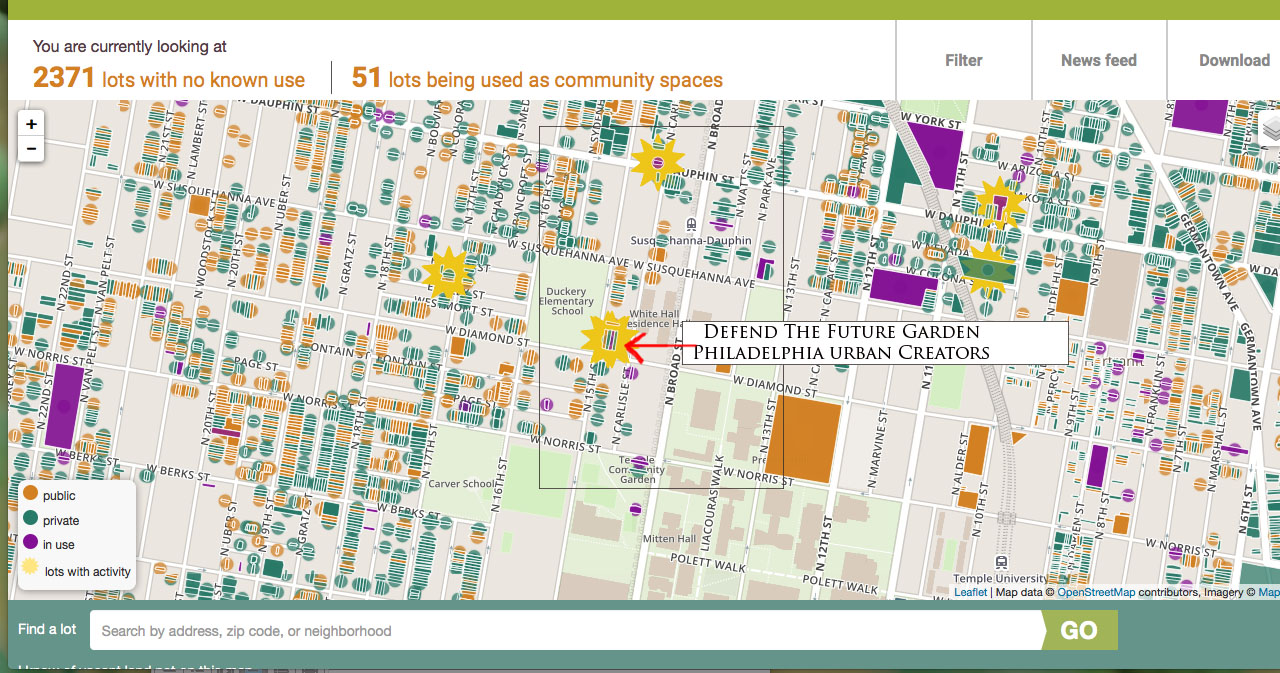
The screenshot shown above comes from a website called Grounded In Philly and the image reveals that nearly 2,400 lots in this image alone are vacant. Grounded In Philly is a great resource that seeks to make vacant land space available to communities in Philadelphia. The mapping data from this website is sourced from Philadelphia’s Records Department, City Planning Commission, the Water Department, Licenses and Inspections and OPA API. A vacant lot is susceptible to increased crime rates, drugs and other violent activity. According to the National Garden Association, “gardens reduce crime, increase citizen involvement, increase property values, empower residents to build stronger ties to their neighborhoods, and provide nutritious food in areas where it may not be readily available.” The presence of a garden is a positive and political act. It is the beginning of change in a space that previously was underutilized.

Figure 5: Map of Residential Burglaries in Philadelphia from January 1, 2014 to November 17th 2014. Location highlighted is the 15th and Diamond Intersection of the Defend The Future Garden. Map displays garden’s location as a high crime area, made known by the dark pink hexagons. Map found on Open Data Philly’s website.
Figure 2: Map of Residential Burglaries in Philadelphia from January 1, 2014 to November 17th 2014. Location highlighted is the 15th and Diamond Intersection of the Defend The Future Garden. Map displays garden’s location as a high crime area, made known by the dark pink hexagons. This map was created before the vacant lot became a garden. Map found on Open Data Philly’s website.

There are over 40,000 vacant lots in Philadelphia, and the Defend The Future Garden is not one of them. This is about a success story. This lot is in close proximity to an elementary school, basketball court, a bookstore, a fraternity, a bike shop, several corner stores and residential houses from both transient Temple students and a large African American community with deep historical roots. The garden has a partnership with the elementary school and is working to give teachers access to use the garden as an outdoor classroom for their students.

Figure 3: ArcGIS Land Use Map (red circle is Defend The Future Garden) All the brown lots are considered vacant.

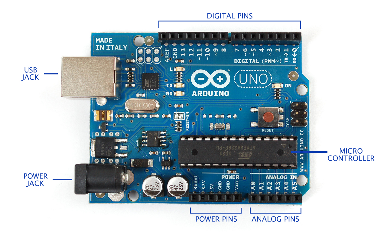
Stay tuned for the next If Gardens Could Talk post which will dig into the technology of arduinos (the garden’s future brain) and the growing DIY maker movement.

arduino_desktop

Leave a Reply

You must be logged in to post a comment.

Recent Posts

  • Web Scraping Wikipedia to Analyze XBOX Game Development Companies by Nationality January 4, 2023
  • Critical Elements for Making Games December 22, 2022
  • Cities as Havens for Bees: Using Remote Sensing to Visualize Urban Bee Habitat December 21, 2022

Tags

3D modeling 3D printing 360 video arduino augmented reality authorship attribution coding corpus building critical making Cultural Heritage data cleaning data visualization digital art history Digital Preservation digital reconstruction digital scholarship film editing games GIS linked open data machine learning makerspace mapping network analysis oculus rift omeka OpenRefine Photogrammetry physical computing Python QGIS R SketchUp stylometry text analysis text mining textual analysis top news twitter video analysis virtual reality visual analysis voyant web scraping YouTube

Archives

©2023 Loretta C. Duckworth Scholars Studio | Design: Newspaperly WordPress Theme