Skip to content

Loretta C. Duckworth Scholars Studio

⠀

Menu
  • Scholars Studio Blog
    • Digital Methods
      • coding
      • critical making
      • data visualization
      • digital pedagogy
      • immersive technology (AR/VR)
      • mapping
      • textual analysis
      • web scraping
    • Disciplinary Fields
      • Anthropology
      • Archaeology
      • Architecture
      • Art History
      • Business
      • Computer Science
      • Critical Digital Studies
      • Cultural Studies
      • Dance
      • Economics
      • Education
      • Environmental Studies
      • Film Studies
      • Gaming Studies
      • Geography
      • History
      • Information Science
      • Linguistics
      • Literary Studies
      • Marketing
      • Media and Communication Studies
      • Music Studies
      • Political Science
      • Psychology
      • Public Health
      • Sculpture
      • Sociology
      • Urban Studies
      • Visual Art
    • Cultural Analytics Practicum Blogposts
  • Current Staff
  • Newsletter
  • About
    • Games Group 
Menu

Beginning Stages of Terrain Modeling

Posted on September 22, 2015April 22, 2020 by

By Joyce Rasing

I am interested in violent non-state actors’ (VNSAs) terrorist campaigns whilst linking their mode of attack and target type with the terrain in which the incident occurs. I found inspiration for this project after reading Miles Kahler’s “Collective Action and Clandestine Networks: The Case of Al Qaeda”[1] in Spring 2014. I had decided to narrow the scope in which I work on this project-I looked at the FBI’s Most Wanted Terrorists list and decided to narrow in on a Filipino terrorist group which finds its roots in Islamic fundamentalism. Two[2] out of 28 individuals on this list is outwardly associated with the group I am researching, Abu Sayyaf. Over this semester, you can expect project developments in two areas:

  1. terrain analysis of islands of the southern part of the Philippines with the location of Abu Sayyaf events since its inception[3] which delineates their modes of attack and their target types over time
  2. social network analysis after data mining articles archived of these events. I want to find out more information about the individuals that were involved in these campaigns.


Here are the beginning stages of Part 1 of my project:

QGIS Philippines-Location of some Abu Sayyaf terrorist attacks.
Figure 1: Geocoded elements of some Abu Sayyaf terrorist attacks in the Philippines ranging from 1994-2014 in QGIS.


What: What you’re viewing are a few of the 7,000+ islands of the Philippines in their southern region, along with geocoded locations of Abu Sayyaf terrorist attacks by x- and y- coordinates listed from the Global Terrorism Database[4]. These locations will not remain simple points, but are starting indicators of Figure 2 listed below. I am storing the dates in which they occur for a later stage in Part 1 of my project in case there are correlations between seasonal attacks, and/or patterns over the years.

Software Used: QGIS has an OpenLayers plugin and you are viewing the Philippines in Google OpenStreetMap. Also in the picture, streets and municipality shapefiles[5] are open on the screen. I plan to work more with this once I can focus on specific clusters of incidents.


QGIS-Contour-DEMhillshade
Figure 2: You’re looking at an example of the contour lines I formed from Philippines’ DEM data for an island called Panglima-Sugala; also where two Abu Sayyaf attacks occurred.


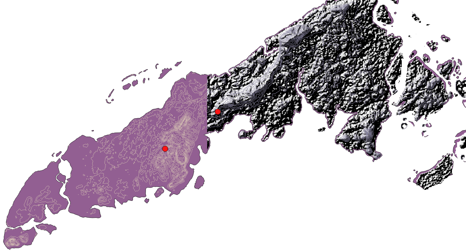
What: I grabbed digital elevation model (DEM) data from the CGIAR-CSI website which is SRTM (NASA Shuttle Radar Topography Mission) data, and then will create contour lines to show elevation. This is currently what I am working on, and have exemplified the difference between contour lines and a hillshade effect from DEM for visual purposes and the content will be edited in upcoming steps of the project. I am also exploring other raster datasets that use a different type of sensor. As I move forward, I’ll be able to determine which dataset is the most effective at achieving the end goal.

Software: I have been working back and forth with QGIS and ArcGIS for this terrain. I plan to make progress by finishing the building of the contour lines, as well as look for patterns among the attacks listed by the Global Terrorism Database.


Data:

CGIAR-CSI

Jarvis A., H.I. Reuter, A.  Nelson, E. Guevara. (2008). SRTM 90m Digital Elevation Database v4.1. (2008).

Retrieved from CGIAR-CSI SRTM 90m Database http://srtm.csi.cgiar.org.


Global Terrorism Database

National Consortium for the Study of Terrorism and Responses to Terrorism (START). Global Terrorism

      Database 1992-2010 Dataset (June 2015). Retrieved from http://www.start.umd.edu/gtd.


National Consortium for the Study of Terrorism and Responses to Terrorism (START). Global Terrorism

      Database 2011-2014 Dataset (June 2015). Retrieved from http://www.start.umd.edu/gtd.


PhilGIS

Tongco, A. F.  Philippine GIS Data Clearinghouse (PhilGIS). Country Boundary (2013).

Retreived from:  http://www.philgis.org/freegisdata.htm. 

—

[1] Kahler, Miles. Collective Action and Clandestine Networks: The Case of Al-Qaeda to Networked Politics: Agency, Power, and Governance, 103-24. Cornell
Studies in Political Economy. Ithaca, NY: Cornell University Press, 2009.

[2] I.T. Hapilon and R. Sahiron.

[3] There will be plenty of limitations based on the data that I use. As of September 17, 2015, I am only using one data source until I can find more and/or credible databases eligible for use, or gather enough information to add to the map.

[4] The Global Terrorism Database (GTD) remains the only credible source of information that I’m using to map the locations of these attacks.

[5] The cons of the shapefiles and DEM data that I am using is that they are outdated by a few years. I am on the quest for updated and free data files that I can use for my project, however, it is not exactly my top priority until I analyze the importance of the terrorist campaigns.

Leave a Reply

You must be logged in to post a comment.

Recent Posts

  • The Untold History of Fletcher Street’s Stables April 21, 2025
  • Building an Immersive Archive of the Greek Orthodox Churches in Istanbul April 15, 2025
  • Tracing Influence in Genealogies of Communication Theory April 14, 2025

Tags

3D modeling 3D printing arduino augmented reality banned books coding corpus building critical making Cultural Heritage data cleaning data visualization Digital Preservation digital reconstruction digital scholarship film editing game design games gephi human subject research linked open data machine learning makerspace makerspace residency mapping network analysis oculus rift omeka OpenRefine Photogrammetry Python QGIS R SketchUp stylometry text analysis text mining textual analysis top news twitter video analysis virtual reality visual analysis voyant web scraping webscraping

Recent Posts

  • The Untold History of Fletcher Street’s Stables April 21, 2025
  • Building an Immersive Archive of the Greek Orthodox Churches in Istanbul April 15, 2025
  • Tracing Influence in Genealogies of Communication Theory April 14, 2025

Archives

Meta

  • Log in
  • Entries feed
  • Comments feed
  • WordPress.org

Archives

Blog Tags

3D modeling (11) 3D printing (14) arduino (8) augmented reality (5) banned books (3) coding (12) corpus building (4) critical making (7) Cultural Heritage (11) data cleaning (4) data visualization (11) Digital Preservation (3) digital reconstruction (9) digital scholarship (12) film editing (3) game design (3) games (6) gephi (3) human subject research (3) linked open data (4) machine learning (6) makerspace (8) makerspace residency (4) mapping (30) network analysis (17) oculus rift (8) omeka (3) OpenRefine (4) Photogrammetry (5) Python (8) QGIS (10) R (9) SketchUp (4) stylometry (8) text analysis (10) text mining (4) textual analysis (32) top news (102) twitter (5) video analysis (4) virtual reality (17) visual analysis (5) voyant (4) web scraping (16) webscraping (3)

Recent Posts

  • The Untold History of Fletcher Street’s Stables April 21, 2025
  • Building an Immersive Archive of the Greek Orthodox Churches in Istanbul April 15, 2025
  • Tracing Influence in Genealogies of Communication Theory April 14, 2025
  • From Theory to Practice: Weaving in Response to the Grid in the Global Context March 26, 2025
  • Visiting a Land of Twilight February 24, 2025

Archives

©2025 Loretta C. Duckworth Scholars Studio | Design: Newspaperly WordPress Theme
Menu
  • Scholars Studio Blog
    • Digital Methods
      • coding
      • critical making
      • data visualization
      • digital pedagogy
      • immersive technology (AR/VR)
      • mapping
      • textual analysis
      • web scraping
    • Disciplinary Fields
      • Anthropology
      • Archaeology
      • Architecture
      • Art History
      • Business
      • Computer Science
      • Critical Digital Studies
      • Cultural Studies
      • Dance
      • Economics
      • Education
      • Environmental Studies
      • Film Studies
      • Gaming Studies
      • Geography
      • History
      • Information Science
      • Linguistics
      • Literary Studies
      • Marketing
      • Media and Communication Studies
      • Music Studies
      • Political Science
      • Psychology
      • Public Health
      • Sculpture
      • Sociology
      • Urban Studies
      • Visual Art
    • Cultural Analytics Practicum Blogposts
  • Current Staff
  • Newsletter
  • About
    • Games Group