Although my work incorporates data from a diverse set of disciplines, my own tools principally lie within three areas:
1. Field Mapping
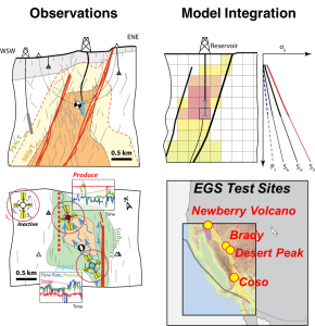
The type, associating, and geometry of structures in a fault zone are a record of the physics and the mechanisms that govern fault behavior. Exhumed fault and fracture networks provide the critical observations to develop and test the mechanical models that explain the behavior of the brittle earth.
- Detailed structure maps: getting on the outcrop is essential to identifying the type, timing, and relationships among structures comprising a fault or system of fractures
- Laboratory analysis (thin sections, X-ray diffraction, X-ray fluorescence): seeing types of materials, pore space, and how they are organized in a structure from the micron to the grain scale
- Balloon & UAV Photography/Photogrammetry & LiDAR: Detailed basemaps for these observations can now be built from low level, high resolution imaging tools
- 3D models of outcrops and structures
2. Borehole Geophysics
The brittle crust extends to many kilometers depths. Direct observation of the mechanics governing faults, earthquakes, and reservoir systems occur at depths only accessible through boreholes. Using boreholes we can observe fractures and faults and the stress states imposed on them.
- Wireline well logging including image logs and physical property logs
- Drillers logs
- Injection studies
3. Computer Simulations
Test how individual structures are related, interact, and combine into a mechanical system. Computer simulations enforce mechanical rules to explore and test the relationships evident in the field or in boreholes.
- Boundary Element Methods
- Linear Elastic Fracture Mechanics (LEFM
Project Partners
- Geothermal: Ormat, CYRQ Energy, AltaRock Inc., Navy GPO, USGS, Washington State Geological Survey
- InSAR and GPS: Kurt Feigl (U. Wisconsin)
- Rock Mechanics: USGS
- Seismology: LLNL, LBNL