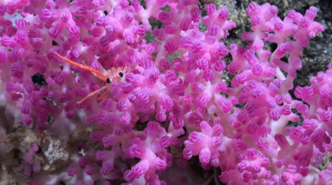
The Phoenix Islands Protected Area (PIPA) is the largest and deepest UNESCO World Heritage Site on Earth. Approximately the size of California, PIPA was the first Marine Protected Area (MPA) of its kind. Created in 2008, it is about halfway between Hawaii and Fiji within the territorial waters of the Republic of Kiribati. Above the water, eight low-lying islands exist in the MPA, but the real beauty is below the surface. Huge tracts of deep ocean are pierced by over 25 underwater volcanoes. Seamounts along with atolls and submerged reefs create one of the last isolated coral archipelago ecosystems, virtually untouched by mankind. The biological density is phenomenal with more than 500 fish species, an abundance of sharks and turtles, and at least 120 types of coral – but that is just in the shallows. PIPA is also the first protected area in Pacific where depths exceed 16,400 feet (5,000 meters), and entirely unknown species are sure to live at those depths.
In October 2019, our team explored never seen before seamounts and atolls within PIPA. Along with Remotely Operated Vehicle (ROV) SuBastian, the science team conducted some of the first ROV dives in these locations. The dive missions provided a first glimpse of many of these habitats to discover what PIPA is protecting at these depths, and inform the future management of this area. We discovered many new species of corals, and reef-forming stony corals where they were not believed to be able to survive. We also explored how swift countercurrents running along the equator create boundaries from north-to-south, but also connections from east-to-west, providing a better understanding of coral connectivity across the Pacific.
Schmidt Ocean Institute website