Collaborators:
Steve Hasiotis (University of Kansas), H. Allen Curran (Smith College), Daniel Hembree (University of Tennessee), Jon Smith (Kansas Geological Survey), Brian Platt (University of Mississippi)
LITHOLOGICAL ANOMALIES IN SANDS: IMPLICATIONS FOR VERTEBRATE ICHNOLOGY
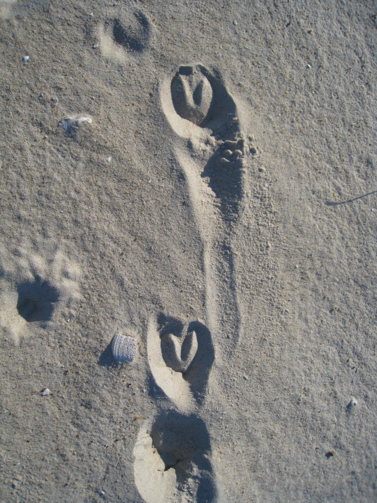
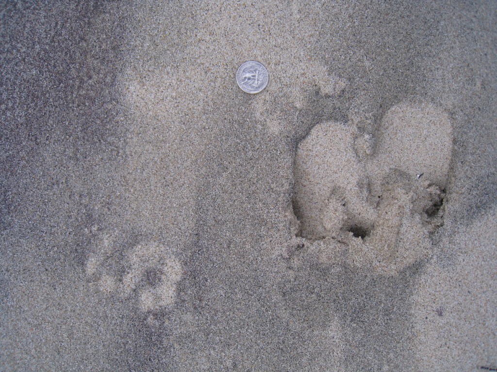
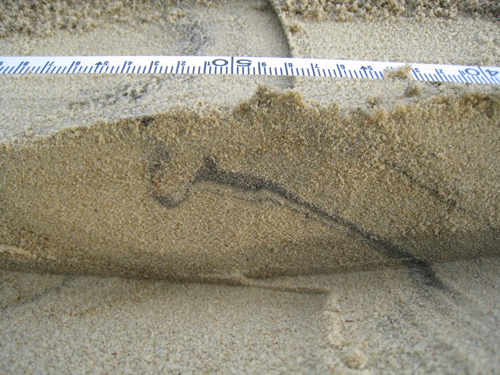
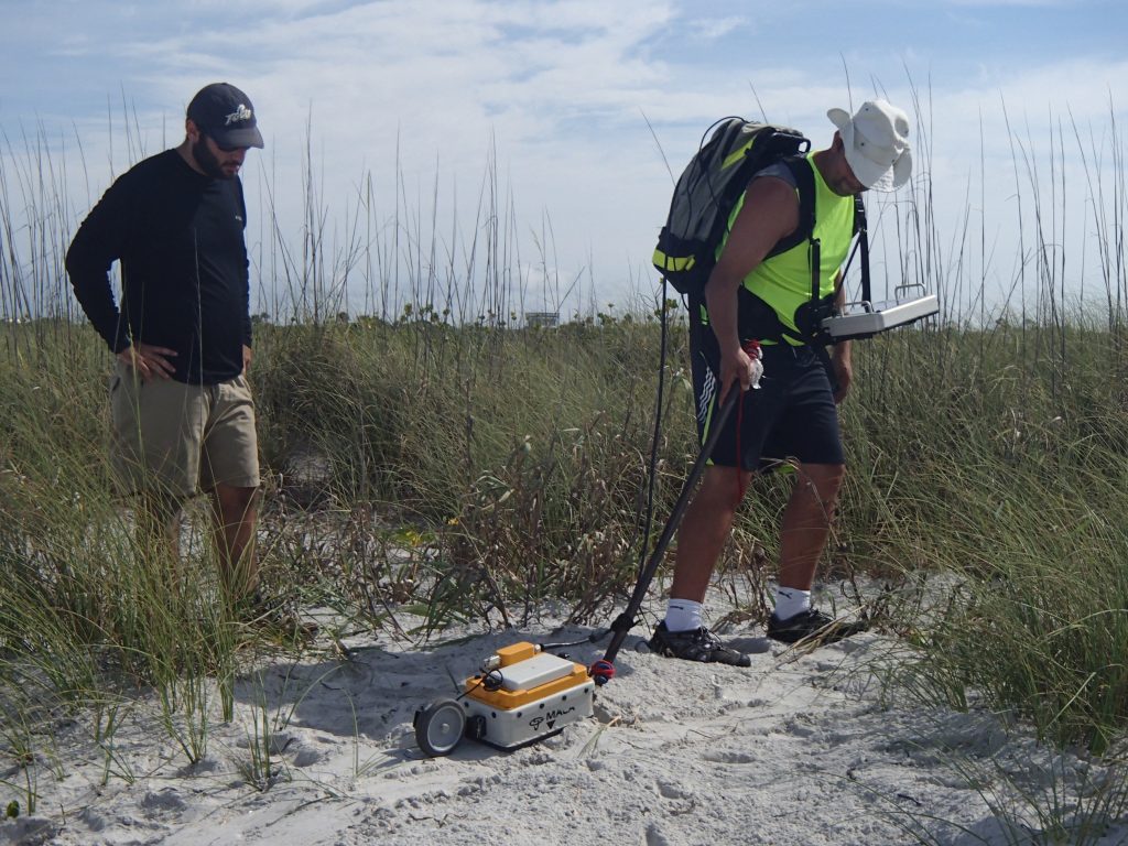
Despite the dynamic nature and coarse texture of sandy substrates, many studies report abundant vertebrate and invertebrate tracks, from Paleozoic sandstones to Holocene depositional environments. Track preservation in sand typically requires moisture or clay laminae, but in mid-high latitudes freezing before burial may also increase substrate strength and resistance to erosion. Recognition of tracks in plan-view and cross-section remains a challenge, especially in unconsolidated sands. In many coastal and aeolian settings, lithological anomalies, such as heavy-mineral concentrations (HMCs), represent density lag formation during episodes of increased wave or wind activity. HMCs not only act as environmental indicators, but also accentuate vertebrate and large invertebrate tracks due to their darker color. Using examples from the U.S. East Coast and Eastern Europe (Baltic Sea coast), this project examines the occurrence of avian and mammalian footprints in beach and aeolian HMCs. During post-storm periods or intervals of non-deposition, surficial heavy-mineral concentrations may serve as distinct tracking surfaces. In cross-section, even thin HMCs (1-3 mm) accentuate the shapes of traces and associated structures, as exemplified by a possible cervid track preserved in 1,100-year-old dune slipfaces at the Baltic Sea site. Since many HMCs are enriched in magnetite, low-field magnetic susceptibility (MS) can be used for in situ analysis of track and undertrack laminae. With sub-centimeter sensitivity, a decrease in MS from magnetite-enriched surface laminae (>50×10-5 SI) to quartz-rich track fill (<5) helps constrain track parameters. Where HMC thickness is comparable to the resolution of a ground-penetrating radar (GPR) signal, they produce sharp subsurface reflections. This method is useful for detecting deformation features ranging from 20 cm to less than 2 cm using antenna frequencies between 400 MHz and 2.3 GHz, respectively. Some irregular laminations in shallow subsurface images may potentially represent trampled surfaces and caution must be taken in interpreting them as primary sedimentary structures. Future field and experimental research must combine MS and GPR imaging of vertebrate tracks to better understand how lithological anomalies reflect the final track architecture.
MODERN VERTEBRATE TRACKS FROM COASTAL LITHUANIA: REGIONAL DISTRIBUTION ANDTAPHONOMIC FACTORS
Donatas Pupienis (Vilnius University, Lithuania), Albertas Bitinas (Klaipeda University, Lithuania), Aldona Damušytė (Lithuanian Geological Survey)
The formation and preservation of vertebrate traces in modern settings provides a useful guide to locating and analyzing their counterparts in sand-dominated coastal and aeolian sequences. A diverse suite of vertebrate footprints along the Baltic Sea coast offers insights into the distribution and preservation potential of tracks in sandy substrates. At the mainland beach site of Butinge, northernmost Lithuania, artiodactyl (deer) and mustelid (?) tracks occur behind the foredune ridge, with canid (fox) tracks found in association with deep excavations in back dunes. At the southernmost Curonian Spit site, three types of avian footprints occur on the high-energy Baltic Sea beach, along the low-energy Curonian Lagoon shoreline, and on a 50-m-high slipface of the active Parnidis Dune. Mammal traces along the lagoon shoreline include numerous canid tracks (also found on nearby steep dune slopes), suid (wild boar) trackways and trampled surfaces, and a few mustelid footprints. Shore-perpendicular aquatic rodent trackways, drag traces, and gnaw marks suggest that beaver activity is more prominently displayed than that of a recently introduced muskrat. Cervid (elk and deer) trackways follow trails across high vegetated dunes. Based on the wide use of horses on the spit for at least 700-800 years, their hoofprints may be preserved in the shallow subsurface of dune and beach sequences. The habitat preferences result in a predictable distribution of track assemblages allowing differentiation between the open sea vs. lagoon shoreline, stable vs. active dunes, and coastal forest (palve). The medieval phase of dune reactivation contains deformation structures interpreted as tracks with marginal ridges. Although scientific names are not used for modern tracks, once preserved in plan view of cross-section, it is reasonable to apply Vialov’s (1966) ichnotaxonomy to those footprints which readily resemble their recent counterparts and have been used for some Cenozoic tracks (Canipeda, Cervipeda, Hippipeda, Mustelipeda, Suipeda, etc.). Surface moisture, occasional freezing, rapid aeolian burial, and lithological anomalies (heavy-mineral concentrations) increase the preservation potential of tracks. Once buried, the attitude of trackways with respect to bedding surfaces determines their ultimate context.
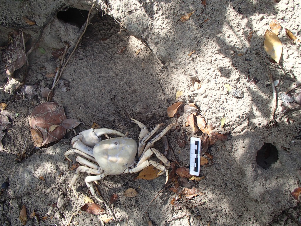
NEOICHNOLOGY AND ZOOGEOMORPHOGY OF LARGE DECAPODS IN COASTAL CARBONATES: THE BAHAMIAN LAND CRABS
H. Allen Curran (Smith College)
NEOICHNOLOGY WITH ROVs: DEEP-SEA FISH TRACES AND SEDIMENT RE-SUSPENSION IN THE EASTERN MEDITERRANEAN
Collaborators:
Rami Tsadok, Max Rubin, Zvi Ben Avraham (Leon H. Charney School of Marine Sciences, University of Haifa, Israel), Dwight Coleman, Robert Ballard (URI/IFE), James A. Austin Jr. (University of Texas-Austin), Jake Benner (Tufts University).
Observations by two remotely-operated vehicles (ROVs) at
four sites along the bathyal region (500-2,000 m) offshore Israel revealed
multiple traces produced by benthic and bentho-pelagic fish that reflect
near-bottom activity in one of the most biologically impoverished regions of
the World Ocean. High-resolution video and screen captures from the main
tethered ROV Hercules were complemented by Argus photography
from 15 m above the seafloor to provide a broad view of medium-scale (10-20 cm) biogenic structures.
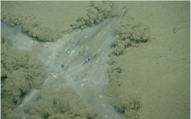
Piscine traces made in soft or partially compacted muddy sediments include grooves, circular and semi-circular depressions, swimming and lateral sliding trails, as well as “resting” traces reflecting sheltering, nesting, and camouflaging/ambush behavior by scorpionfish, rays, eels, flounder, blennoid species, and others.
In most cases, the tracemakers were observed in the process of producing the
biogenic structures or using burrows and depressions made by other fish and
invertebrates. Several types of the imaged traces and seafloor disturbances are
known from the rock record (Undichna and Piscichnus ichnogenera). Their
preservation depends on sedimentation rates and overprint by subsequent
bioturbation. Near-bottom video also captured various behaviors leading to
sediment re-suspension by fish, both through near-bottom contact by pectoral,
pelvic, anal, and caudal fins, and by rapid collision with the seafloor. The
latter may have been due to ROV approach, but the behavior could be considered
analogous to predator avoidance or search for epifaunal or infaunal prey. A similar behavioral response was observed in several species of deep-water squid. Large (1-2 m long) grooves of deep-diving cetaceans (e.g., Cuvier’s beaked whales) were absent from all sites, but were observed in the vicinity of underwater volcanoes in the northern Mediterranean during other legs of this expedition and by earlier researchers.
The present study demonstrates that abundant fish traces and sediment re-suspension events represent important processes in the bathyal eastern Mediterranean, shedding new light on benthic species abundance and diversity, constraining the residence time of sediments and nutrients, and offering analogs for biogenic structures and trace fossil assemblages in deep-water shales.
VERTEBRATE SWIM TRACES ON A LATE TRIASSIC LACUSTRINE PALEO-SURFACE, BUCKS COUNTY, PENNSYLVANIA
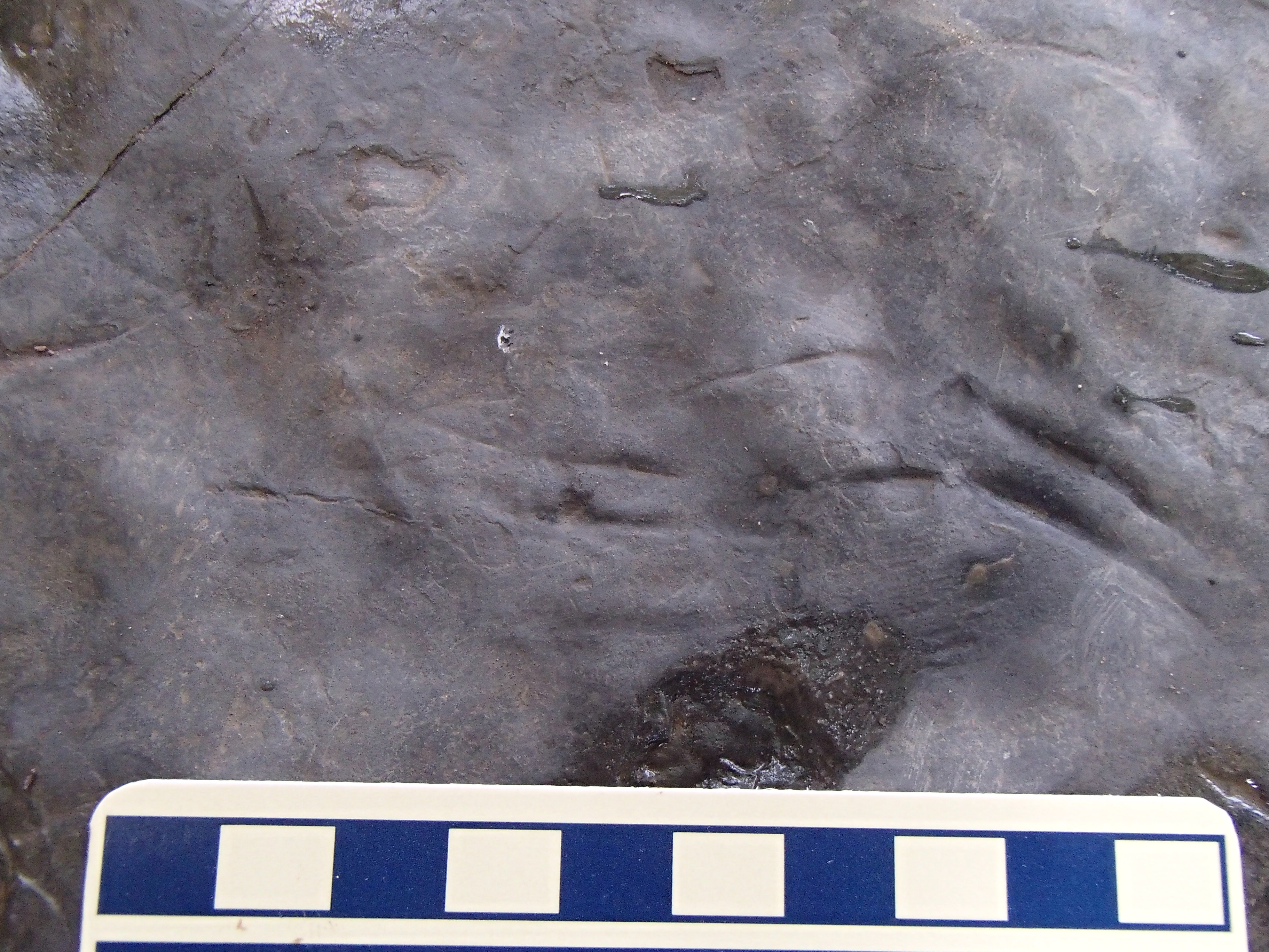
Bedding planes of numerous quarried mudstone blocks of Lockatong Formation (Carnian, Late Triassic) in Northampton Township, Pennsylvania, exhibit a variety of lake-margin physical structures (ripples, mudcracks) and invertebrate trace fossils. One boulder surface is covered by ~50 sets of slightly curved, sub-parallel striations that are interpreted as bottom contact marks produced by a buoyed organism. Triple (>70%) and double grooves exhibit occasional cross-cutting and juxtaposition. Although directionality, straddle, and limb type cannot be determined, the traces are designated as probable digits II, III, and IV of a vertebrate tracemaker. The sets are 12.5-22.1 mm in total (II-IV) width (with up to 20% asymmetry of II-III/III-IV distances), with lengths varying from 9.3-34.9 mm. Their geometry, 1-3 mm depth, and gradually sloping interdigital surfaces are indicative of claw marks. Thin sections reveal soft-sediment deformation of black clay and light gray silt laminae below each striation. Slightly asymmetric cross-sections and progressive lateral deepening within most 3-digit sets imply a horizontal force component. More than 80% of trace orientations range within 15° of azimuth, consistent with a (uni)directional movement. Although fish were abundant in lacustrine settings of the Newark Basin, they are excluded as tracemakers due to low sinuosity and discontinuity of striation sets. Therefore, we interpret these marks as tetrapod swim traces (Characichnos isp.), with examples of various sizes described in many Mesozoic sequences. Tetrapod ichnogenera of comparable dimensions previously described from the Lockatong and Passaic Formations include Gwyneddichnium (attributed to aquatic tanystropheid archosauromorphs) and Rhynchosauroides (lepidosauromorph/primitive archosauromorph), with Batrachopus (crocodylomorph) typically found in younger (post-Carnian) successions. These reptiles are represented by skeletal remains in lacustrine deposits and are likely responsible for the swim traces. With pentadactyl feet used for propulsion, only two or three longest toes likely contacted the soft substrate. The shallow-water traverse by a group of animals was followed by lake desiccation, as evidenced by large mudcracks and uniform surface oxidation post-dating the traces.
Zoogeomorphology
Collaborators:
H. Allen Curran (Smith College), Michael Savarese (Florida Gulf Coast University)
MEGAVERTEBRATE ACTIVITY ALONG OCEANIC COASTS: SPANNING THE ICHNOLOGICAL-ZOOGEOMORPHIC CONTINUUM
The impact of large reptiles (sea turtles), birds (penguins), and mammals (pinnipeds) on coasts ranges from ephemeral traces to landform scales. Pinniturbation is proposed as a general term for substrate reworking by flipper action. Building on pioneering work along Georgia barrier islands, a suite of sea turtle traces (polychresichnia) is expected to include approach/exit crawlways (repichnia), a compound body pit/egg chamber/cover pit structure (calichnia), as well as hatchling escape (fugichnia/taphichnia) and associated predation (praedichnia/mordichnia) traces. Each nest structure may affect >2 m3 of sediment, with philopatry ensuring that many nesting sites remain preserved in prograded coastal sequences (swales within strandplains) where they may be misinterpreted as storm-surge scour structures. Beyond sediment advection on feet and bodies, burrow excavation (domichnia/calichnia) by several penguin species generates new landforms in coastal peatlands and other soft substrates. Pinnipeds cause the greatest impact on mid-high latitude rocky coasts, with dramatic disturbance of terrestrial ecosystems, especially trampling of native insular vegetation. During haul-outs on beaches, >150 m3 of sediment can be reworked by a herd of 1,000 individuals. Locomotion traces of true seals (phocids) distinguish them from more upright tread-like trackways of fur seals, sea lions, and walruses. On mixed sand-gravel beaches, pinniped interaction and wallowing may reactivate deflation basins. The microtopography produced by animal activity locally affects sediment dynamics and wave focusing along upper berm and dune sites. On the beachface, trace preservation is reduced due to tidal processes. During the past century, the scale of pinniturbation was likely at its minimum, compared to that prior to hunting campaigns and following recent population rebounds. Surficial (LiDAR) and subsurface (georadar) imaging are emerging as effective means of identifying, mapping, and monitoring megavertebrate structures. Future research will focus on paleogeography (shoreline position and trend, paleo-water table), ichnology (ichnotaxonomy and ichnocoenoses), geophysics (geoclutter), geoarchaeology (resource exploitation by maritime cultures), and conservation of protected species.
ZOOGEOMORPHIC AGENTS IN MID-ATLANTIC FLUVIAL, AEOLIAN, AND COASTAL BIOTOPES
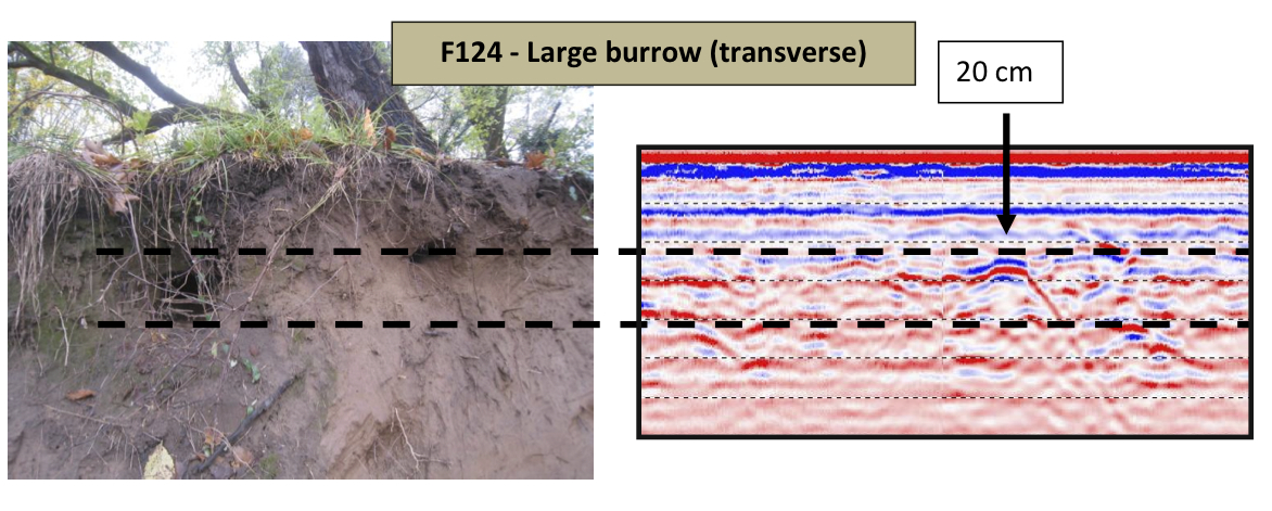
Along with the growing role of humans as geomorphic agents, native or introduced animals exert varying degrees of impact on ground vegetation, sediment cohesion, slope stability, water infiltration, and related critical-zone processes. The historic role of beavers as landscape engineers in fluvial and lacustrine settings often masks the cumulative impact of other animals. Stream bank bioturbation has been the focus of levee protection efforts, but requires more attention by fluvial geomorphologists along sites inhabited by semiaquatic rodents, birds (e.g., bank swallows), and fish (catfish). Along small streams with habitual deer fording sites, hoof penetration may exceed 5 cm, leading to accelerated bank erosion through slumping and focused runoff. Georadar imaging is being increasingly applied as an effective means of non-invasive 2D and 3D characterization of large animal burrows, including northern pine snakes in paraglacial aeolian plains of New Jersey and large (>0.5 m3) rodent burrow complexes in the bluffs of the lower Delaware River. The latter tend to increase the vulnerability of outer terrace segments to storm-induced erosion, mass wasting, and treethrow. On coastal barriers inhabited by ungulates, vegetation removal through natural grazing is compounded by edge-loading action of artiodactyls (deer, boar). At Assateague Island (MD/VA), pediturbation by herds of feral horses results in surface reworking (sediment advection, compaction) that may exceed10,000 m3/hour of activity. Rooting and wallowing produce lasting deflation basins with potential for aeolian reactivation, whereas shallow excavations and burrowing (e.g., nesting estuarine and sea turtles) introduce microtopographic anomalies along intertidal and berm regions. In the supratidal zone, foxes, rodents, and ghost crabs are responsible for extensive excavations (>5,000 cm3/burrow) that may induce localized surface lowering through enlargement and collapse. Although often seasonal and site-specific, the impact of a particular species may leave a long-term legacy, including formation of secondary drainage pathways, erosional reactivation corridors, and biomantles. Therefore, recognition, mapping, and quantification of the rates and extent of biogenic activity must be incorporated into morphodynamic models.

