
In 2017, I was an intern for the Borough of Emmaus, a small borough of roughly 11,000 people located in eastern Pennsylvania. While employed, I was tasked with creating a map of the entire borough that was required to show certain datasets and information. The information that was required included storm water pipes, water flow direction, outfalls, inlets, bodies of water, retention areas (present and proposed), manhole covers, and elevation contours. All of this information was required by a program being run by the State of Pennsylvania entitled the “MS4 program”. Creating of the program was done to comply with the federal clean water act, with the main goal being cleaning up the pollutants in our bodies of water.
One of the main challenges I was working with regarding this project was that I was the only person employed by the Borough that knew how to work a GIS software, let alone know what GIS even is. This was an obstacle I did not think I was getting myself in to. Trying to explain the processes that were happening and needed to be completed to other borough employees was challenging. Another facet of this issue was that I didn’t have a single person to bounce ideas off of o anyone to ask a question to if I got stuck. For someone that never worked a job using GIS and still completing their bachelor’s degree, this was a massive learning curve. Another major problem I had to deal with was the borough didn’t have any type of GIS data readily available. Some datasets I had to download (like borough boundaries and aerial imagery), while others I had to manually create by myself. All of the storm water pipes were hand drawn onto paper maps by the water department and I had to spend quite a lot of time digitizing every pipe segment as well as inputting the attribute data associated with each segment. For one man to complete nearly one thousand pipe segments, this took some time.
Once all of the leg work was completed and compiled onto a functioning map, it was then able to be submitted. For the borough, since they did not have any GIS professionals on staff, they first sent the finished map to be revised by an engineering firm that specialized in this municipal storm water program. A few weeks later, they approved the map and it was submitted to the state department of environmental protection.
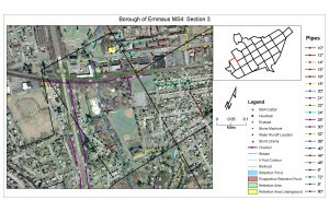
As seen below, this map is only a subsection of the much larger map. Subsections were created to be able to get much better resolution of every storm water pipe and so the water department could carry these maps with ease.
All in all this project and internship was a difficult task for me at the time and made me learn a lot about GIS and the GIS profession in a short amount of time. Just because a project may sound easy doesn’t necessarily mean it will be just that. A lot of times there are various issues and problems that are encountered which increase the difficulty of the project. It is important to learn and adapt to every project that comes in front of a GIS user, and I learned doing this will make you a much better GIS professional in the future.