If you read my previous post on Burk Mansion, located at 1500 N. Broad St. Philadelphia, you will recall my thoughts on the building’s relationship to its present day surroundings. In order to gain a greater sense of where the property fits into the urban landscape, I decided to look at a number of historical maps. These maps range from the 1750s to 2018 and represent over 268 years of change. The present day location of Burk Mansion is indicated with a pin on each map. All of the following images were captured from the Greater Philadelphia GeoHistory Network which allows users to layer various historical maps on top of present day maps.
The first map, comes from the early 1750s created by Nicolas Scull and George Heap. This particular map focuses on the areas outside of the city grid. If you look closely, you can see the homes of individuals as well as street names and prominent geographical features. Obviously Burk Mansion did not yet exist, and it appears as if the present day location was more rural surrounded by several roads, homes, and streams.
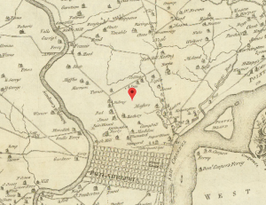
c. 1750 Philadelphia (N. Scull and G. Heap)
This map was produced in 1808 by surveyor John Hills. As you can see, there are more city blocks, including proposals for future city planning. At this point, there are few labeled properties near the present day location of Burk Mansion.
1808 Philadelphia v2 (John Hills)
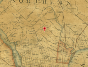
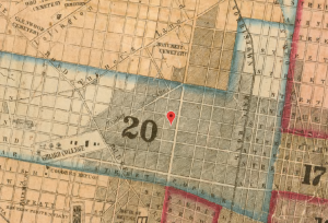
An 1843 map of Philadelphia County demonstrates drastic changes that developed within 35 years. At this point, city blocks have expanded outwards and North Broad Street is now defined. Several properties are identified by last names of owners. The streams are still visible and there are no specific buildings or properties labeled at the present day location of Burk Mansion. Slightly north of the pinpoint, you can see there is now a cemetery.
1843 Philadelphia County (Charles Ellet, Jr.)
The R.L. Barnes map was published only 12 years after the previous one and was the first map published after the consolidation of the city of Philadelphia. This act consolidated all townships, districts, and boroughs into Philadelphia County. Though the map does not mark structures, we can tell the city was experiencing a period of rapid growth. This map was published one year after Alfred Burk’s parents emigrated to Philadelphia from Germany.
1855 Philadelphia City (R.L. Barnes)
An 1862 Philadelphia Atlas shows the development of buildings along present day N. Broad St. Notice the homes and churches being constructed. It seems as if many of the city blocks are empty, waiting to be developed.

1862 Philadelphia Atlas (Samuel L. Smedley)
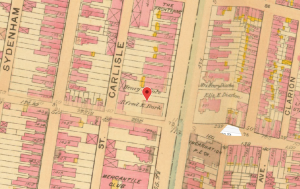
This map from 1875 shows the development of numbered plots. 1500 N. Broad St. is marked under the ownership of Joseph Singerly, an architect and builder. Alfred Burk eventually purchased Singerly’s property.
1875 Philadelphia Atlas (G.M. Hopkins)
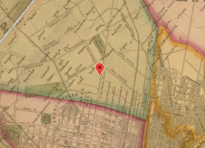
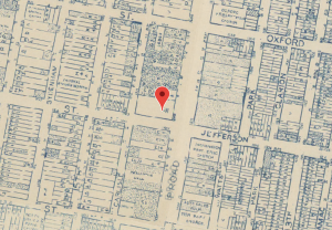
This map from 1895 shows the outlines of buildings on the plots from the previous map. The property of Joseph Singerly is shown with a mansion. When Alfred Burk purchased the property, he demolished the Singerly mansion to construct his own mansion. It is also interesting to note the presence of Temple College, an opera house, a market, a brewery, and a few social clubs. If you look further south, there are also a number of other mansions belonging to prominent Philadelphians including P.A.B. Widener and William L. Elkins.
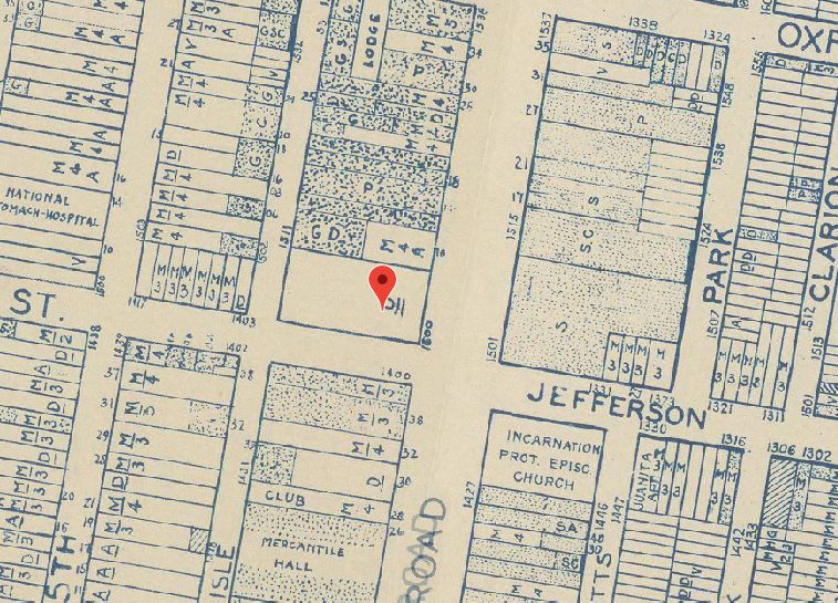
1895 Philadelphia Atlas (G.W. Bromley)
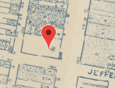
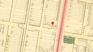
This map from 1910 shows that the property is now owned by Alfred Burk. This map also shows that the structure on the property changed and also shows the conservatory in the back of the property on Carlisle Street. Broad Street is still filled with social clubs, hotels, and entertainment.
1910 Philadelphia Atlas (G.W. Bromley)
The next map is a 1942 land use map and was published after the death of Alfred Burk in 1921. As you can see, the property is unlabeled. At this point, the property was inherited by relatives. In 1943, the property was listed for sale for $100,000. There are still a number of social clubs, entertainment centers, and hotels along Broad Street.
1942 Land Use Maps (Works Progress Administration)
This 1962 map shows new use and ownership of the property. 1500 N. Broad is now labeled as Union Headquarters. According to our class research, we know the mansion housed the Upholsterers International Union of North America, an AFL affiliated union of upholsters and textile workers, among others.
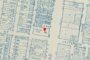
1962 Land Use Maps (Works Progress Administration)
The final image was pulled from Google maps. Google provides a fairly detailed sketch of the mansion, but it is not labeled. It is also interesting to note that it is not labeled under Temple University, despite current ownership.
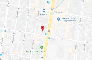
Google Maps Retrieved October 1, 2018
Looking at changes of place over time is helpful for understanding the history and significance of 1500 North Broad Street. Throughout the 268 years represented in the 11 maps above, Burk is only explicitly mentioned once. For the purpose of this project, these maps tell much more than the story of Alfred Burk. Rather, they tell a story of change and continuity over time which gives us insight into larger patterns of Philadelphia’s urban history. When we look at the current status of Burk Mansion and its uncertain future, it is important to remember that its community has been changing and evolving for the past 200 years.
Further Questions:
- What kind of changes in the community have been observed in the past 5-10 years? How are these changes similar and/or different from the changes demonstrated from these maps?
- What makes change in a community good or bad? Who makes that judgement? Is it possible to have change that is beneficial to the community as a whole?
- Imagine yourself 50 years in the future. What does this section of North Broad look like on a map given its current patterns of change?